https://engineering.purdue.edu/Stratigraphy/charts/rgb.html
Before learning about local geology in San Diego, it helps to have a basic understanding of how the San Diego region formed. We’ll begin by learning about geologic time. The Earth is around 4.56 billion years old, which is a lot of time to cover. To make things easier, scientists use geologic time to break it up, as seen in the picture above from the Geological Time Scale Foundation. San Diego sits on the edge of the Pacific and North American plates, which means that scientists can only trace the rocks back about 150 million years, to the late Jurassic period, the same one from the famous movie. During this period, molten rock flooded the region until around 80 million years ago. From 80 million years ago to the present, sediments have been deposited along San Diego, forming much of the area that we know today including the cliffs along San Diego’s coast. (Patrick Abbott, The Rise and Fall of San Diego)
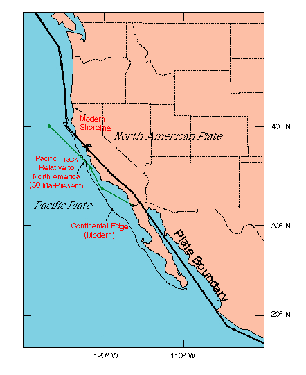
http://walrus.wr.usgs.gov/earthquakes/cencal/P-NAP.html
Did you know that San Diego isn’t even on North American plate? As seen in the picture above, from the United States Geological Survey, San Diego sits on the Pacific plate along with some of Southern California. These plates are in constant motion, and it is their collision that causes the many earthquakes and faults that California is known for. For example, it is the collision of the Pacific and North American plates that forms the famous San Andreas Fault! If you are interested in learning more about the geologic history of San Diego, I recommend The Rise and Fall of San Diego by Patrick Abbott.
Sources:
Abbott, Patrick L. The Rise and Fall of San Diego: 150 Million Years of History Recorded in Sedimentary Rocks. San Diego, CA: Sunbelt Publications, 1999. Print.
