Ocean Beach Tidal Flats

Ocean Beach Tidal Flats

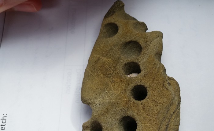
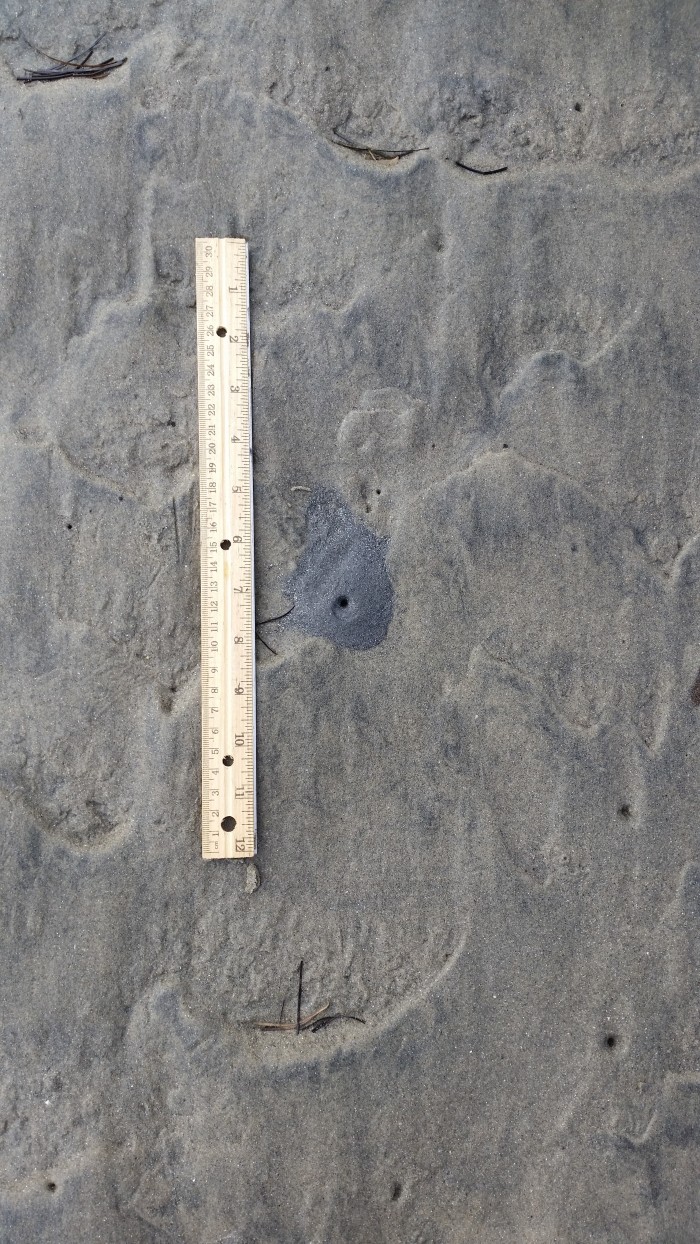
Contrary to popular belief, geologists do more than just stare at rocks.  Many geologists and paleontologists study fossils to gain a better understanding of an area. Trace fossils, which are the traces of an organic organism, are especially useful. Examples of trace fossils include footprints, impressions, burrows, and fecal matter. All of these can become fossilized in the right conditions, preserving them for future geologists to find. If you are interested in seeing examples of these trace fossils in person, the Ocean Beach tidal flats are the perfect place to go. Taking a walk through these tidal flats during low tide will reveal all manner of trace fossils. For example, look at the chunk of sandstone in the picture above. This is an excellent example of a trace fossil that has already become fossilized. The holes in this sandstone were formed by a clam or snail that bored a hole, and have been preserved in the rock. It is a common find in a tidal flat, and doesn’t tell us much. However, if this was found in a desert or at the top of a mountain, it would reveal that the area was once underwater.

095

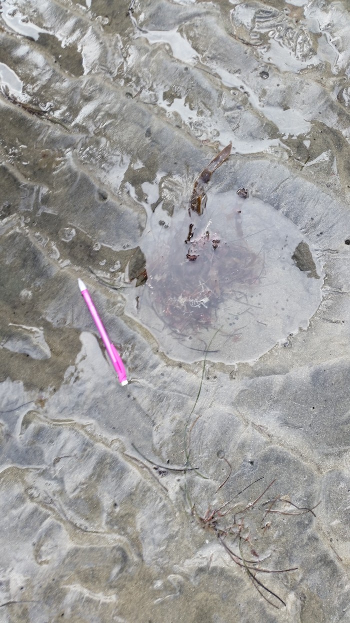
In the picture above is an example of a hole left by a burrowing clam that has not been fossilized yet. This is how the trace fossil from the first picture would have looked before it was fossilized. So how does this hole become fossilized? There are several ways that it could be preserved, but the most common would be if the tide stopped coming in, causing the sand to quickly dry out. This would form a sandstone with a hole in it, similar to the one in the first picture.

099

It is not just clams and snails leaving trace fossils however, much larger animals can leave them too. In this picture is a ray pit, left behind by a stingray that swam in during high tide. While these animals rest on the bottom, they move their fins kicking up the sand. This sand is washed away by the tide, leaving behind this hole, which is another excellent example of a trace fossil. Remember that a trace fossil does not include any part of the animal, they are just tracks or holes left behind by their presence. (Although if you look carefully in the first picture, you can see a snail that took refuge in one of the holes!)

Sunset Cliffs

Sunset Cliffs

056

If you’ve ever walked along the shore at Sunset Cliffs, you were probably looking out at the ocean and not at the cliffs behind you. To a geologist however, those cliffs are far more interesting than the ocean! You see, those rocks contain the story of how the Sunset Cliffs were formed. To understand why these rocks are so important, and how a geologist can read them, we first have to go back to the 17th century. In 1669, Danish scientist Nicolas Steno published his Law of Superposition. This law simply states that when looking at a section of sedimentary rock, the layers on the bottom will have been deposited before the layers on the top. This may not seem like a big deal, as of course layers on the bottom would come first, but this revolutionized the way geologists viewed the world and formed the basis of the modern science of stratigraphy. So how does this apply to Sunset Cliffs? If you look at the photo above you can see alternating layers of tan and gray rock. These are actually two different kinds of rock, with the gray rock being mudstone and the tan rock being sandstone. Using the law of superposition, we can determine the order in which these layers were formed, with lower layers forming before the higher layers. Now that we know the order in which these layers were formed, the next step is to determine the environments that formed these rocks. Mudstone, the dark gray rock, is formed in shallow, calm water. Sandstone, the tan rock, can form in deeper, rougher water. This means that this whole area was underwater while these cliffs were forming. Not only that, the depth of this water was changing between deep and shallow.  This law doesn’t just apply to Sunset Cliffs however, you can use it on any of the cliffs around San Diego, and determine how they were formed.

Sources:

Levin, Harold L. The Earth through Time. Philadelphia: Saunders, 1978. Print.

Geology in San Diego

Geology in San Diego

https://engineering.purdue.edu/Stratigraphy/charts/rgb.html

Before learning about local geology in San Diego, it helps to have a basic understanding of how the San Diego region formed. We’ll begin by learning about geologic time. The Earth is around 4.56 billion years old, which is a lot of time to cover. To make things easier, scientists use geologic time to break it up, as seen in the picture above from the Geological Time Scale Foundation. San Diego sits on the edge of the Pacific and North American plates, which means that scientists can only trace the rocks back about 150 million years, to the late Jurassic period, the same one from the famous movie. During this period, molten rock flooded the region until around 80 million years ago. From 80 million years ago to the present, sediments have been deposited along San Diego, forming much of the area that we know today including the cliffs along San Diego’s coast. (Patrick Abbott, The Rise and Fall of San Diego)

P-NAP.gif

http://walrus.wr.usgs.gov/earthquakes/cencal/P-NAP.html

Did you know that San Diego isn’t even on North American plate? As seen in the picture above, from the United States Geological Survey, San Diego sits on the Pacific plate along with some of Southern California. These plates are in constant motion, and it is their collision that causes the many earthquakes and faults that California is known for. For example, it is the collision of the Pacific and North American plates that forms the famous San Andreas Fault! If you are interested in learning more about the geologic history of San Diego, I recommend The Rise and Fall of San Diego by Patrick Abbott.

Sources:

Abbott, Patrick L. The Rise and Fall of San Diego: 150 Million Years of History Recorded in Sedimentary Rocks. San Diego, CA: Sunbelt Publications, 1999. Print.